Sometime during a random Skype conversation, the idea of climbing Mt. Goode was hatched between JR, O and Joe.
We decided the Beaver was the best way to access the peak.
(Just kidding) We took the boat...We decided the Beaver was the best way to access the peak.

Arriving in Stehikin on the Lady of the Lake, we disembarked and boarded the NPS shuttle which took us 10 miles up the road.


From here we hopped on our mountain bikes an started peddling, hoping to get 5 miles up the trail.

What we thought was going to be just a simple washout and then good road again, turned into over a mile of severely damaged road to no sign of a road whatsoever. We carried our bikes across the first section, it seemed easy enough....

A little waterfall:


and some boulder hopping with a bike - no problem!


O making the moves...

We gave up on the bikes when we needed to use both hands for the boulder problems.

O making the moves...

We got back on good trail and made good time as we hiked another 10 miles to the base of the mountain.


We found a perfect bridge of snow, accessed the rock, changed shoes and started cruising up the rock.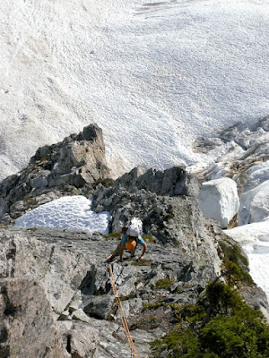
The route was clean and easy to travel and we quickly moved up the route.
Looking back down the route...
We went down


Looking back at the west face of Goode:
We finally made it back to that waterfall. Michelle got vertigo and John assisted her with her bike.

All was going well, we retrieved our bikes hit the road and started back to Stehikin, but then our first big problem. Joe was expertly handling his less than perfect mountain bike down the bumpy terrain when the stem of his tube broke off leaving him flat. This would not have been much of a problem, given we had an extra. But the bicycle pump that we had carried up and over Goode, did not have a nozzle and could not be used. We were stuck, just 1/2 hour from fresh coffee cake and fresh coffee at the bakery with a bunk bike.
JR and O rode on and said see you there. Luckily Michelle was clearly thinking and assured Joe that there would be a pump at the Ranch if we just waited for the shuttle another 10 minutes. We were picked up, pumped up and back on the road. We made it to the Bakery just 15 minutes after JR and O!
Relaxing with some Joe's at the Stehikin Bakery!

We made quick work of the last mile, boarded the fast boat and headed home; but not before jumping in Lake Chelan for a quick swim!


The brush cleared and opened to moraine and we got a great view of the route.
The northeast face of Mt. Goode (center peak) and Storm King Mountain on the right:

The northeast face of Mt. Goode (center peak) and Storm King Mountain on the right:

Below is the line we took. Once off the glacier and on the rock, the route is 2,800 feet of rock climbing. It is mostly very easy 3rd and 4th class climbing, with a few pitches of mid-to-low fifth class. But given the ease of climbing, it is still a huge objective on a remote alpine face.

But before we reached the base of the climb, we still had to cross the North Fork of Bridge Creek and bushwack the way to our bivy site at 5,400 ft, reaching there just before dark.


The glacier was pretty easy to navigate and we quickly made our way to the base of the buttress toe, accessing it on its left side.

The weather was perfect!


We found a perfect bridge of snow, accessed the rock, changed shoes and started cruising up the rock.

The route was clean and easy to travel and we quickly moved up the route.

up and up.....

Looking back down the route...

We topped out around 2 p.m. The weather was perfect!
From left to right; Sahale, Logan, Forbidden and Eldorado peaks


More views of the Cascades from the top...


and more...


John, Olivia, crooked hat and Joe... on the summit


Now the hard part.....THE DESCENT.... (JP says not so hard:)


We went down

and down


and rested. This isn't even close to being over....


Lucky for us, Olivia had been carefully picking out the descent route which did not involve any heinous bushwacking.


It was all smooth sailing through old avalanche paths and meadows.


The view was great

Looking back at the west face of Goode:

We finally made it back to that waterfall. Michelle got vertigo and John assisted her with her bike.

All was going well, we retrieved our bikes hit the road and started back to Stehikin, but then our first big problem. Joe was expertly handling his less than perfect mountain bike down the bumpy terrain when the stem of his tube broke off leaving him flat. This would not have been much of a problem, given we had an extra. But the bicycle pump that we had carried up and over Goode, did not have a nozzle and could not be used. We were stuck, just 1/2 hour from fresh coffee cake and fresh coffee at the bakery with a bunk bike.
JR and O rode on and said see you there. Luckily Michelle was clearly thinking and assured Joe that there would be a pump at the Ranch if we just waited for the shuttle another 10 minutes. We were picked up, pumped up and back on the road. We made it to the Bakery just 15 minutes after JR and O!
Relaxing with some Joe's at the Stehikin Bakery!

We made quick work of the last mile, boarded the fast boat and headed home; but not before jumping in Lake Chelan for a quick swim!
No comments:
Post a Comment